El Niño this winter: what it means for Santa Barbara
NOAA says a strong to very strong El Niño is likely through early 2027, with odds above 83%. Here is what that has meant for Santa Barbara surf and rain in the past, and what the forecast shows right now.
- ENSO status
- El Niño Advisory
- Strong or very strong, Jan to Mar
- >83% odds
- Record event, Oct to Dec
- 83% odds
- Niño 3.4, past month
- +2.1°C
El Niño is here and getting stronger. NOAA's Climate Prediction Center says a strong to very strong El Niño is likely through January to March, with odds above 83%. This post covers what that is, what it has meant for Santa Barbara in past winters, and what the forecast actually shows for the next few weeks.
What El Niño is
El Niño is a warming of the surface ocean in the central and eastern equatorial Pacific. The warm water shifts where tropical rain falls, and that shifts the jet stream.
In winter, NOAA describes the typical pattern as a stronger jet stream and storm track across the southern United States, with the main area where storms form shifting south and east to just west of California. In El Niño winters, that brings a stormier season and more rain to California.
Where it stands now
The latest ENSO diagnostic discussion, issued October 8, has an El Niño Advisory in effect.
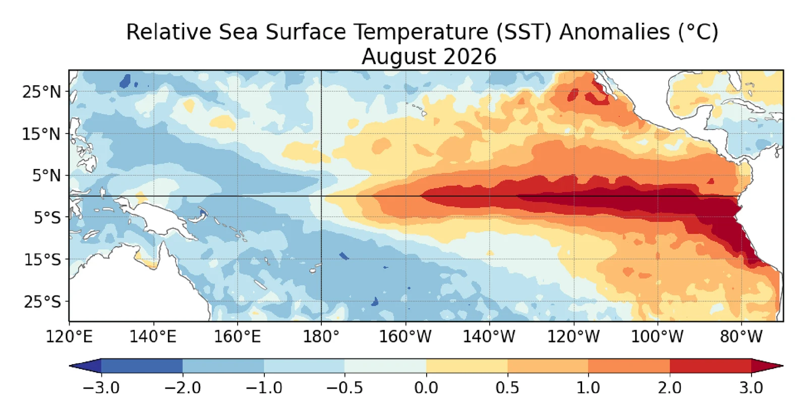
Ocean temperature compared with normal, August 2026. Red is warmer than normal. Source: NOAA Climate Prediction Center.
The key points:
- Niño 3.4: the main index rose to +2.1°C over the past month. Parts of the eastern Pacific are more than 4°C warmer than normal.
- Strength: a strong to very strong event is likely through January to March 2027, with odds above 83%.
- Record potential: an 83% chance that October to December is stronger than any El Niño back to 1950. The odds are 54% for September to November and 70% for November to January.
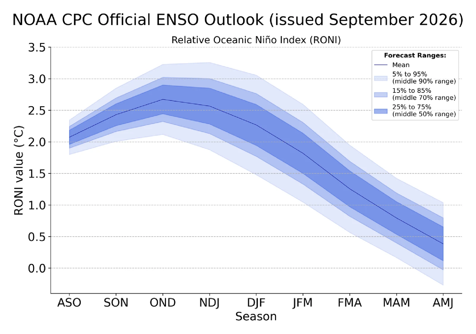
NOAA's September forecast for El Niño strength by season. It peaks in October to December and fades by spring. Source: NOAA Climate Prediction Center.
The seasonal outlook from September 17 tilts the odds toward above normal rain for the southern half of California from October to December. Those odds rise through winter and peak at 50 to 60% near the California coast from December to February and into early spring.
One thing could soften the usual effects. The Pacific Decadal Oscillation is negative this year (an August index of -1.11), and the September outlook says that "may dampen the typical impacts" in some areas.
The next ENSO update is Thursday, November 12. The next seasonal outlook is October 15.
What it means for Santa Barbara surf
The Santa Barbara coast is sheltered. A USGS study of 18 buoys found that Point Conception shelters most of the Southern California Bight from North Pacific weather, and that the Channel Islands selectively block westerly swells entering the Santa Barbara Channel. Surf on the south coast depends on swell arriving at the right angle to slip through the gaps. The buoy guide covers the directions that work.
A strong El Niño helps because it sends more North Pacific storms farther south and closer to California. More storms means more west and northwest swell, and more chances for one to hit the windows. Rincon and the rest of the south coast need exactly that kind of swell.
The same energy hits the beaches. In 2015-16, USGS found that winter wave energy equaled or exceeded measured historical maximums along the West Coast, and that winter beach erosion was 76% above normal, the highest on record.
Storms to watch
Nothing in the near-term forecast is an El Niño winter storm yet. The rain in the forecast comes from tropical moisture and an upper low, not a winter storm off the North Pacific. The El Niño signal is in the seasonal outlooks, not the 7-day.
As of the National Weather Service Los Angeles forecast discussion on October 8:
- Heat: the long heat wave ends today. Saturday highs run 5 to 10 degrees cooler.
- Rachel: its track has shifted south. A Coastal Flood Advisory covers Los Angeles and Ventura County beaches through Tuesday afternoon. Santa Barbara County is not under that advisory, but a Beach Hazards Statement covers the Santa Barbara south coast from Saturday morning through Monday afternoon.
- This weekend into Monday: showers are likely south of Point Conception by Sunday, mostly 0.1 to 0.25 inch. On Monday an upper low moves toward Santa Barbara County, with rain chances across the region. Morning tides run 6.8 to 7.6 feet, and NWS expects Sunday to bring the biggest impacts.
The NWS surf zone forecast has the Santa Barbara County coast at 1 to 3 feet with a low rip current risk through Friday, rising to 2 to 4 feet with a moderate rip current risk on Saturday.
What to expect this winter
El Niño raises the odds of a wet winter. It does not guarantee one.
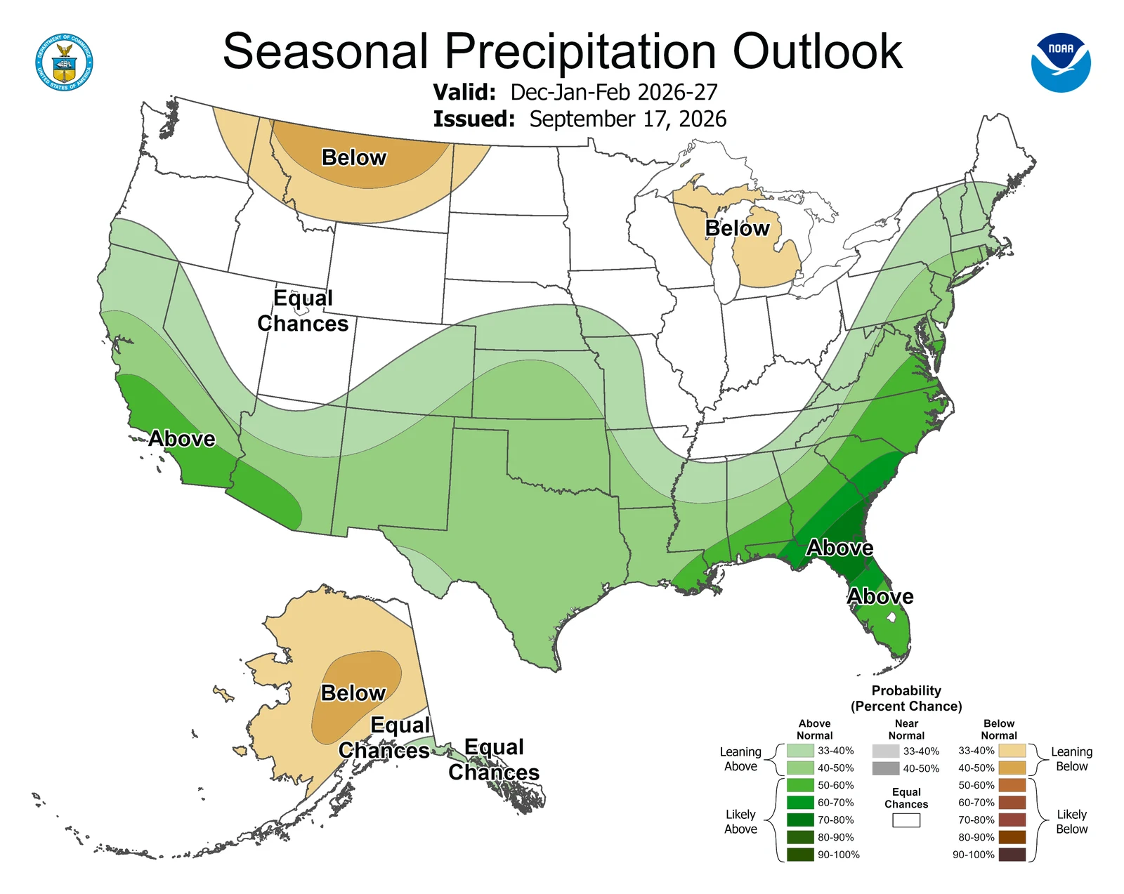
NOAA's rain outlook for December to February, issued September 17. The Southern California coast has a 50 to 60% chance of a wetter than normal winter. Source: NOAA Climate Prediction Center.
Santa Barbara County's rainfall records show the range. According to a county Public Works climate page (archived in 2007), downtown Santa Barbara averaged 23.31 inches in El Niño years, against 18.18 inches overall. Of 39 El Niño years on record, 22 were wetter than normal and 17 were drier. The wettest year on record, 47.07 inches, came in 1998, during the 1997-98 event. The county lists 1983 among its five wettest years and its flood years.
2015-16 went the other way. Southern California got 70% less rain than in the two previous big El Niños, according to USGS. Wave energy was among the largest ever measured, but little sand came down the rivers to rebuild the beaches.
For surfers, the most likely outcome is more west and northwest swell than an average winter, more storm days, and more beach change. For everyone else, expect higher odds of heavy rain from December on, with the details still open. We will update this post as the October outlooks come out. Check the Santa Barbara forecast for the day-to-day picture.